Collection: Nautical Charts

Nautical Charts

Nautical charts are available in two general formats: physical charts, which are printed on paper and electronic charts, which are displayed on an electronic chart display and information system (ECDIS). Each type of nautical chart may be purchased online or ordered over the telephone.

British Admiralty nautical charts are produced by the United Kingdom Hydrographic Office (UKHO) and have been updated to conform to the most recent notices to mariners. They conform to nautical chart carriage requirements detailed in in Safety of Life at Sea (SOLAS) Chapter V Regulation 2.2 and also meet the carriage requirements in SOLAS Chapter V Regulation 19.2.1.4.

Nautical charts and other information services provided by the UKHO are widely-regarded as standard-setting in the industry. British Admiralty nautical charts are designed to provide mariners with the most up-to-date nautical information and keep fleets in compliance with prevailing legislation; legislation that is intended to keep crews safe.

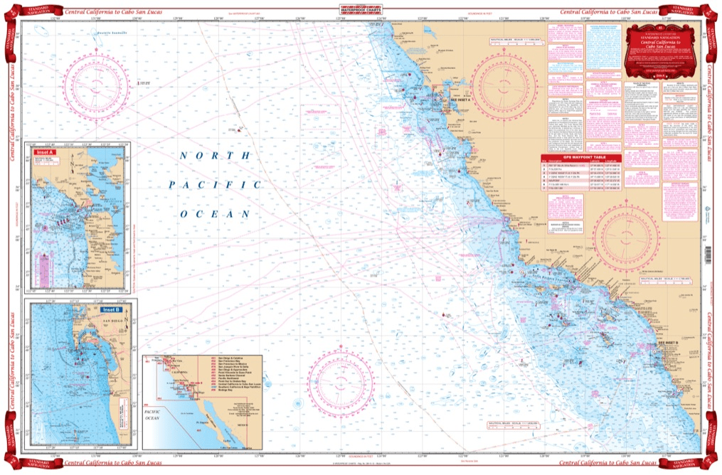
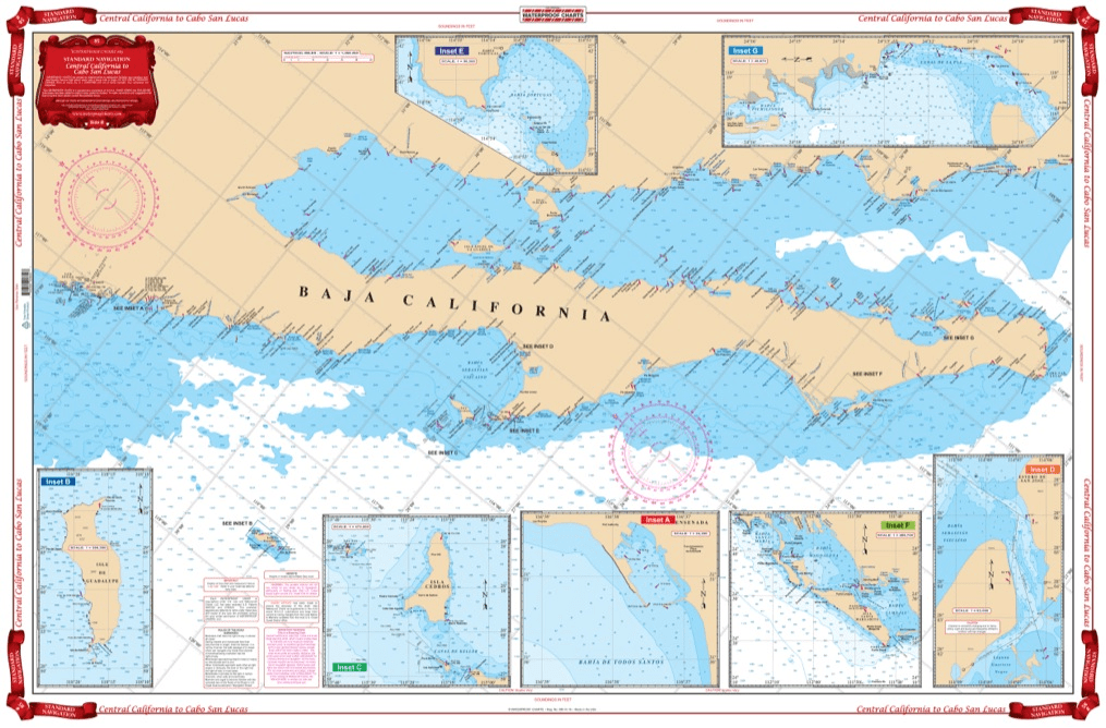
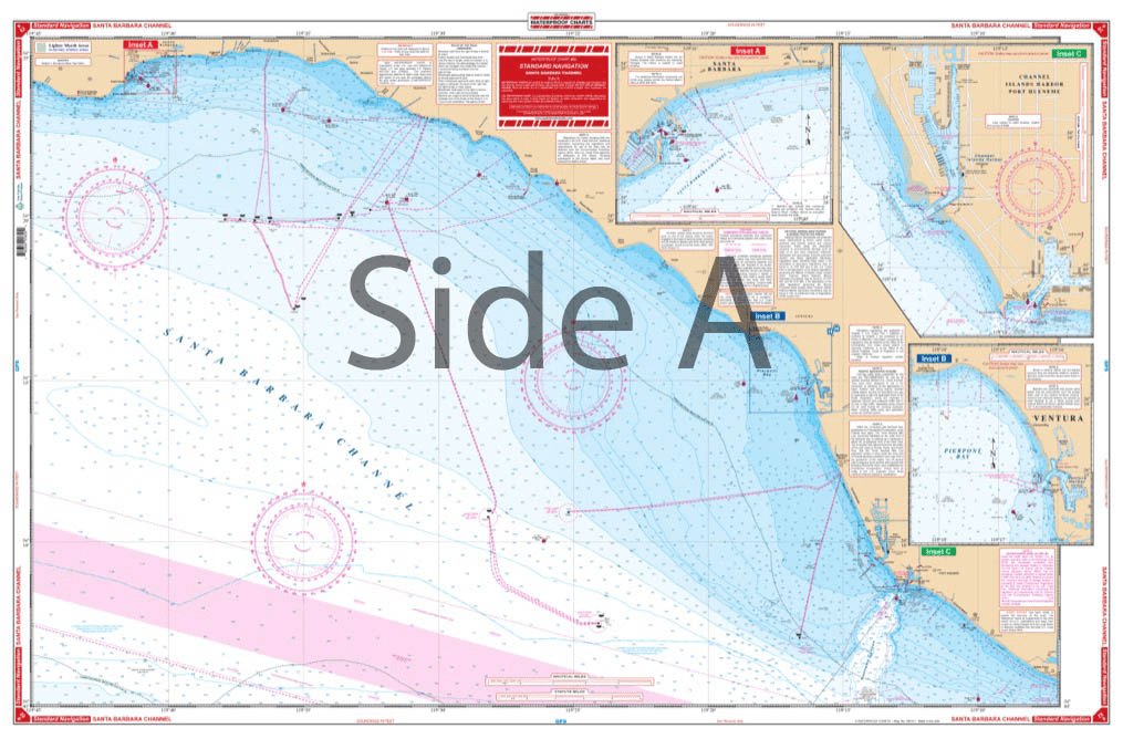
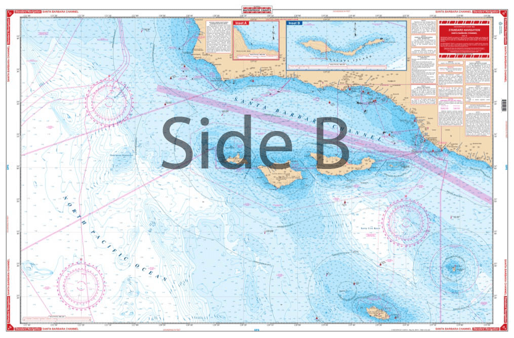
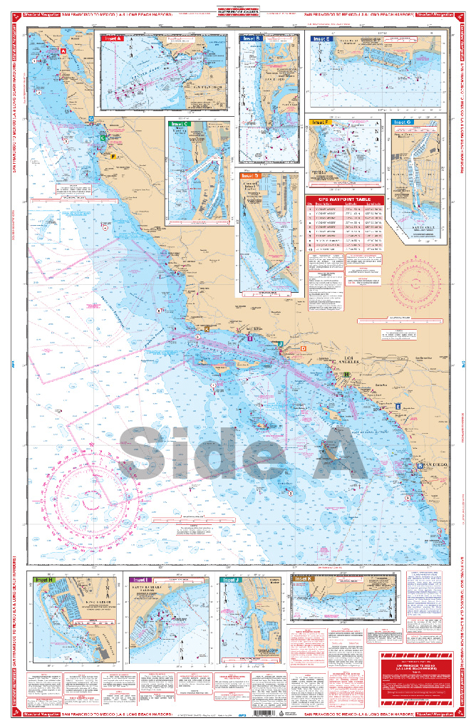
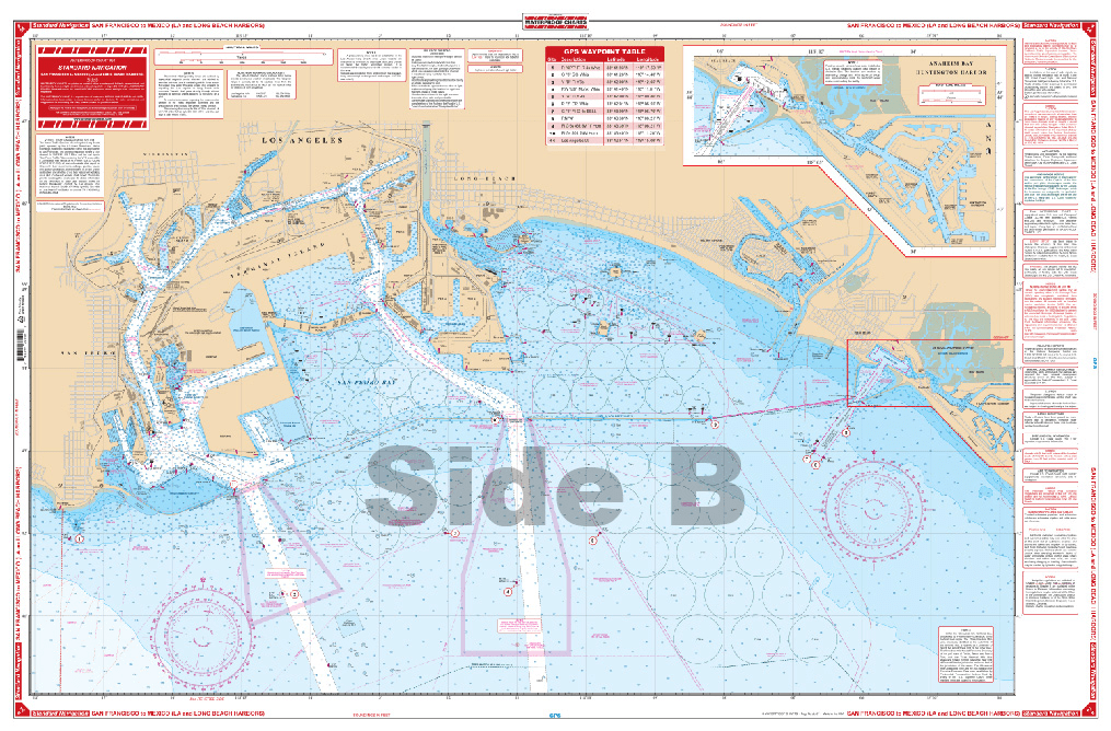
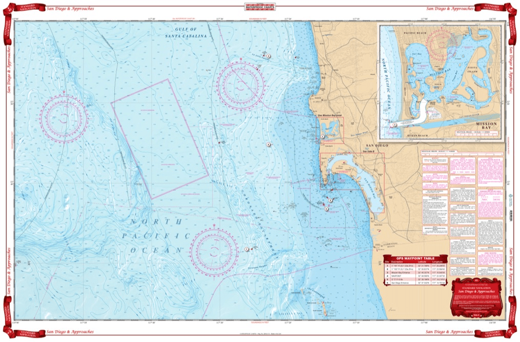
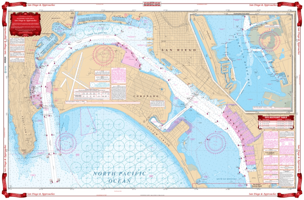
The U.S. National Oceanic and Atmospheric Administration (NOAA) also produces high-quality nautical charts that comply with SOLAS Chapter V Regulation 2.2 carriage requirements and also meet the carriage requirements in SOLAS Chapter V Regulation 19.2.1.4. NOAA nautical charts are printed "on-demand" so that they are updated to include the most recent information available.

NOAA nautical charts have an equally impressive provenance and are highly regarded for their accuracy, ease-of-use and durability. NOAA charts are printed on water resistant paper, which is specifically designed to stand up to wet and damp maritime environments.

All nautical charts available are updated to include information provided by NOAA and UKHO as reported in notices to mariners. It is important that mariners with carriage compliance requirements stay aware of subsequent notices to mariners and update their chart libraries accordingly.

British Admiralty charts produced by the UKHO and NOAA nautical charts are available for a range of locales. Browse the entire selection of British Admiralty and NOAA nautical charts that are available. Mariners are bound to find the nautical chart they need to stay safe and compliant in the list of titles available online from British Admiralty and NOAA nautical charts. No matter where your voyage will take you, British Admiralty and NOAA have the charts you need to plan a successful passage and remain compliant with your flag state's nautical chart carriage requirements.

Filter By
799 of 7842 products
Recreational Charts Recreational Charts Clear all
Sale
Imray Chart C19: A Coruña to Gibraltar
Sale price
$34.95
List price
$39.95
See Product Details
Sale
Imray Chart C15: The Solent
Sale price
$34.95
List price
$39.95
See Product Details
Sale
Imray Chart C1: Thames Estuary
Sale price
$34.95
List price
$39.95
See Product Details
Sale
Imray Chart C18: Western Approaches to the English Channel & Bay of Biscay
Sale price
$34.95
List price
$39.95
See Product Details
Sale
Imray Chart C12: Eastern English Channel Passage Chart
Sale price
$34.95
List price
$39.95
See Product Details
Sale
Imray Chart B4: Tobago
Sale price
$34.95
List price
$39.95
See Product Details
Sale
Imray Chart A281: Anchorages in Guadeloupe, Les Saintes and Marie-Galante
Sale price
$34.95
List price
$39.95
See Product Details
Sale
Imray Chart A271: North Coast of Antigua
Sale price
$34.95
List price
$39.95
See Product Details
Sale
Imray Chart A301: Martinique - South and East Coasts
Sale price
$34.95
List price
$39.95
See Product Details
Sale
Imray Chart A23: Virgin Islands and St Croix
Sale price
$34.95
List price
$39.95
See Product Details
Sale
Imray Chart A14: San Juan to Isla de Vieques and Isla de Culebra
Sale price
$34.95
List price
$39.95
See Product Details
Sale
Imray Chart A12: Punta Figuras to Bahia De Guanica
Sale price
$34.95
List price
$39.95
See Product Details
Sale
Imray Chart C23: Fife Ness to Moray Firth
Sale price
$34.95
List price
$39.95
See Product Details
Sale
Imray Chart C20: Strait of Gibraltar to Arquipelago dos Açores and Islas Canaries
Sale price
$34.95
List price
$39.95
See Product Details
Sale
Imray Chart C14: Plymouth Harbour and Rivers
Sale price
$34.95
List price
$39.95
See Product Details
Sale
Imray Chart C10: Western English Channel Passage Chart
Sale price
$34.95
List price
$39.95
See Product Details
Sale
Imray Chart B2: Barbados
Sale price
$34.95
List price
$39.95
See Product Details
Sale
Imray Chart A26: Barbuda
Sale price
$34.95
List price
$39.95
See Product Details
Sale
Imray Chart A25: St Eustatius, St Christopher, Nevis, Monserrat and Saba
Sale price
$34.95
List price
$39.95
See Product Details
Sale
Imray Chart A141: Cabo San Juan to Ensenada Honda and Isla de Vieques
Sale price
$34.95
List price
$39.95
See Product Details
Sale
Imray Chart A13: Cabo San Juan to Culebra Is and Punta Figuras
Sale price
$34.95
List price
$39.95
See Product Details
Sale
Imray Chart A11: Bahia De Guanica to Punta Borinquen
Sale price
$34.95
List price
$39.95
See Product Details
Sale
Central California to Cabo San Lucas Maxi Navigation Chart 85
Sale price
$27.95
List price
$39.95
Sale
Santa Barbara Channel Navigation Chart 82
Sale price
$27.95
List price
$39.95
Sale
Southern California and Baja Offshore Fish and Dive Chart 88F
Sale price
$27.95
List price
$39.95
Sale
San Diego and Catalina Navigation Chart 51
Sale price
$27.95
List price
$39.95
Sale
San Francisco to Mexico Navigation Chart 54
Sale price
$27.95
List price
$39.95
Sale
Sold out
San Diego and Approaches Navigation Chart 80
Sale price
$27.95
List price
$39.95
Sale
Naples Inshore Fishing Chart 4F
Sale price
$27.95
List price
$39.95
Sale
Key West and Lower Keys Lobster Inshore Fish and Dive Chart 110F
Sale price
$27.95
List price
$39.95
Sale
Florida Middle Keys Inshore Fishing Chart 34F
Sale price
$27.95
List price
$39.95
Sale
Puget Sound Navigation Chart 30
Sale price
$27.95
List price
$39.95
Sale
Jacksonville to St. Augustine Inshore Fishing Chart 44F
Sale price
$27.95
List price
$39.95
Sale
Richardson's Maptech Weather-Tite Carrier
Sale price
$24.95
List price
$29.95
Sale
Bathymetric Chart Plate-4: CHESAPEAKE/ANNAPOLIS
Sale price
$24.95
List price
$27.95
Sale
Bathymetric Chart Plate-12: CHESAPEAKE/POCOMOKE SOUND
Sale price
$24.95
List price
$27.95
Sale
Bathymetric Chart Plate-1: CHEAPEAKE/BALITMORE
Sale price
$24.95
List price
$27.95
Sale
Bathymetric Chart PI-2PT1-2: EASTERN SIGSBEE ESCARPMENT Pt.1 And Pt.2
Sale price
$24.95
List price
$27.95
Sale
Bathymetric Chart PI-1PT2: CENTRAL CALIFORNIA COAST
Sale price
$24.95
List price
$27.95
Sale
Bathymetric Chart PI-1PT1: CENTRAL CALIFORNIA COAST
Sale price
$24.95
List price
$27.95