
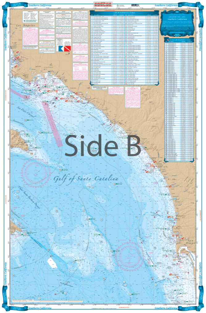

This chart covers the area south from Pt. Dume to south of Descanso, Mexico at 32 degrees north latitude and offshore 60 nautical miles. It includes a total of 444 plotted and indexed GPS positions for rocks, banks, wrecks, artificial reefs, fishing, and 171 diving locations. Added features of this chart include spot specific species and season identifiers for fish, navigation points for major harbors, high quality land detail, and much more. The combination of government charts, local knowledge, and GPS locations make this chart a great value. Whether you are a serious fisherman, or just enjoy having your line in the water, you will want this Southern California and Baja Fishing chart. This fishing chart covers the area south from Point Dume to south of Descanso, Mexico at 32 degrees north latitude and offshore 60 nautical miles. It includes a total of 444 plotted and indexed GPS positions for rocks, banks, wrecks, artificial reefs, fishing, and 171 diving locations. Added features of this marine map include spot specific species and season identifiers for fish, navigation points for major harbors, high quality land detail, and much more. The combination of NOAA charts, local knowledge, and GPS locations make this navigation chart a great value. Information from 2 NOAA charts #18740, and #18766. Nautical Chart is 25″ X 38″. WGS84 – World Mercator Datum.


Thank you for the quick response and delivery of the book I ordered. I have ordered items from your company before and have receive outstanding service every time. It is especially needed because I live and work in Japan for the Navy.
American Nautical never disappoints, these are my favorite triangles as I find they are the most durable. Great customer service, fast shipping.
The chart is nice. Erasing smudges a little and can still see it.
Store have a good library for maritime education
Price, speed of delivery, and no cost shipping made American Nautical Services unbeatable. Thanks for getting me the Windward Islands cruising guide so quickly and at a great price. Many Thanks - John Dockter