
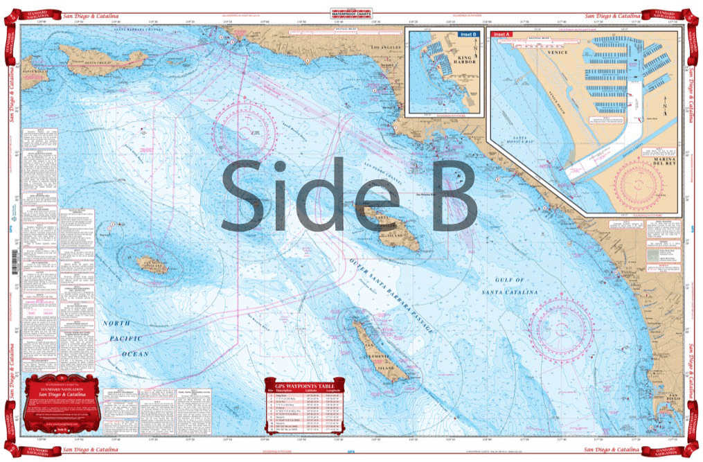
From Santa Barbara south to San Diego, this chart covers the waters offshore to San Nicholas Island with details for Santa Monica Bay and Marina Del Rey and King Harbor on one side. The reverse side details Santa Catalina Island with detailed blow ups for Isthmus Cove and Two Harbors, Avalon Bay, and Catalina Harbor. GPS Waypoints are printed directly on the chart. For journeys between San Diego and Catalina Island, this nautical map has all the detail you need. From Santa Barbara south to San Diego, this navigation chart covers the waters offshore to San Nicholas Island with details for Santa Monica Bay and Marina Del Rey and King Harbor on one side. The reverse side details Santa Catalina Island with detailed blow ups for Isthmus Cove and Two Harbors, Avalon Bay, and Catalina Harbor. GPS waypoints are printed directly on the navigation map. If you are a regular in the area, or want to remember your trip, have this navigation chart framed and display it in your home or office. Information from 3 NOAA Charts: #18740, #18744 and #18757. Nautical Chart is 25″ X 38″. WGS84 – World Mercator Datum.


Thank you for the quick response and delivery of the book I ordered. I have ordered items from your company before and have receive outstanding service every time. It is especially needed because I live and work in Japan for the Navy.
American Nautical never disappoints, these are my favorite triangles as I find they are the most durable. Great customer service, fast shipping.
The chart is nice. Erasing smudges a little and can still see it.
Store have a good library for maritime education
Price, speed of delivery, and no cost shipping made American Nautical Services unbeatable. Thanks for getting me the Windward Islands cruising guide so quickly and at a great price. Many Thanks - John Dockter