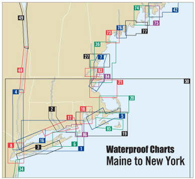
If you're navigating the beautiful coastline from Cape Ann, Massachusetts to Cape Elizabeth, Maine, you need a reliable guide. Our Cape Ann to Cape Elizabeth Waterproof Chart, 3rd Edition, is specifically designed for sailors, boaters, and outdoor enthusiasts who require accuracy and durability at sea.
This premium Waterproof Chart features a stunning new shaded-relief "3D" format, making it not only functional but visually engaging. You'll find GPS waypoints for major buoys, ensuring safe navigation throughout your maritime journey. With a scale of 1:106,666, this chart provides detailed insets that give you valuable information about key coastal areas.
Key features of this Waterproof Chart include:
- Durable and waterproof material that stands up to harsh marine conditions.
- Enhanced clarity with shaded-relief imagery to better visualize coastal features.
Measuring 24" x 36", this chart is an essential tool that fits perfectly in your boating gear. Whether you’re charting a course for a relaxing day on the water or undertaking an adventurous sailing expedition, this chart ensures that you stay informed and to navigate with confidence.
Experience the coastline like never before. Don't leave your navigation to chance; choose the Cape Ann to Cape Elizabeth Waterproof Chart, expertly crafted by Richardson's Maptech.