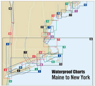
Navigate the waters between Block Island, Rhode Island, and Nantucket, Massachusetts with confidence using the Block Island to Nantucket Waterproof Chart, 5th Edition. This comprehensive marine chart is a vital resource for all boating enthusiasts, from casual sailors to seasoned mariners.
Designed with precision, this Waterproof Chart measures 24" x 36" and is created on a scale of 1:106,666. It provides essential information for a safe and enjoyable journey across one of the busiest waterways in the northeastern United States.
Key features of this waterproof marine chart include:
- Detailed waypoints for major buoys to help guide your course.
- Information on 63 wreck sites, ensuring you are always aware of submerged hazards.
- Ramp locations and launching information to make your outings as smooth as possible.
This chart not only helps you plan your journey with accurate courses and distances but also stands up to the wear and tear of marine environments due to its waterproof properties. Whether you’re mapping out a fishing trip or a leisurely sail, this chart ensures you have the necessary details at your fingertips.
Stay informed and prepared with the Block Island to Nantucket Waterproof Chart, your essential companion on the water!