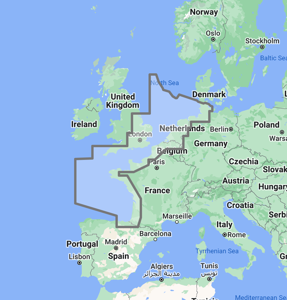
Timezero TZ Map: North Sea, English Channel, Gulf of Viscaya
Price
$300
No reviews
The TimeZero TZ Map: North Sea, English Channel, Gulf of Biscay delivers comprehensive navigational coverage for the highest-traffic maritime corridor in the world, connecting the Atlantic approaches of western France to the North Sea basin shared by the United Kingdom, the Netherlands, Belgium, Germany, Denmark, and Norway. Built on the advanced TZ Maps platform developed by TimeZero, this chart pack integrates multiple chart types, official hydrographic raster charts, detailed vector data, high-resolution bathymetric data, and satellite imagery into a single navigational package supporting safe passage through waters where commercial shipping density, tidal complexity, offshore energy installations, and weather exposure converge to create a uniquely demanding navigation environment.
Coverage encompasses the English Channel from the Western Approaches through the Dover Strait, the full North Sea basin from the Thames Estuary and the Belgian coast north to the Skagerrak entrance, the southern Norwegian coast, the German Bight, the Dutch and Belgian coastlines, and the Gulf of Biscay from the Brittany peninsula south through the French Atlantic coast to the Spanish border. This region carries a staggering volume of maritime traffic: over 500 commercial vessel movements per day transit the Dover Strait alone, the North Sea supports one of the world’s largest concentrations of offshore wind and oil/gas installations, and the Gulf of Biscay serves as the critical link between the English Channel and the Iberian Atlantic coast.
Raster data within the TZ Map is georeferenced, featuring digital images of official hydrographic office charts from five national services: the United Kingdom Hydrographic Office (UKHO), SHOM (France), the Netherlands Hydrographic Office, the German Federal Maritime and Hydrographic Agency (BSH), and the Belgian Hydrographic Service. These agencies collectively maintain some of the most intensively surveyed and frequently updated chart coverage in the world, reflecting the commercial, military, and recreational importance of these waters. Vector data complements raster imagery with a layered database recording every nautical feature, delivering queryable depth information, traffic separation scheme boundaries, offshore installation positions, anchorage zone limits, and navigational object data across the full coverage area.
The BathyVision feature provides dynamic 3D bottom data display essential for navigating the extensive sandbank systems of the southern North Sea, the shifting shoals of the English Channel approaches, and the shallow estuary entrances that provide access to major European ports. High-definition satellite imagery options are available for selected port areas and popular anchorages.
Compatible with TimeZero Navigator v5, TimeZero Professional v5, and Furuno NavNet TZtouch4 (sold separately).
Overview
Feature Highlights Strip
Navigate with integrated raster and vector chart data sourced from official hydrographic offices and enriched with detailed nautical features.
Visualize the bottom structure with high-resolution bathymetry and BathyVision 3D contour mapping.
Overlay satellite photography with chart data.
View realistic shoreline altimetry and perspective horizons.
Customize chart display by toggling layers.
Compatible with TimeZero Navigator v5 and Professional v5.
High-Resolution Bathymetry
Navigate Sandbanks and Shallow Approaches with Confidence
High-resolution bathymetric data transforms chart contour lines into intuitive 3D bottom representations, providing essential depth awareness when navigating through the sandbank-dominated waters of the southern North Sea, the tide-scoured channels of the English Channel, and the shallow bar crossings that guard access to major estuarine ports. The graphic interpretation of contour data creates detailed bottom profiles invaluable for passage planning and approach timing in waters where available depth changes dramatically with every tide cycle and where sandbank positions can shift between survey updates.
The BathyVision feature displays bottom topography in color and contour line overlays, allowing mariners to dynamically adjust the visualization to suit their navigation needs. This capability is particularly critical across this coverage area, where the southern North Sea between the Thames Estuary and the Dutch coast presents extensive sandbank systems including the Goodwin Sands, the Flemish Banks, and the Dutch coastal shoals that reduce available water to single-digit meters across wide areas, the English Channel narrows to approximately 34 kilometers at the Dover Strait, concentrating the world’s busiest shipping traffic into a confined waterway where depth awareness and traffic management are inseparable, the Gulf of Biscay’s shallow continental shelf along the French coast transitions abruptly to deep oceanic water at the shelf edge, creating swell amplification zones and complex wave patterns that affect vessel routing, and major European port approaches including Rotterdam (Europoort), Antwerp, Hamburg, Le Havre, and Brest involve extended transits through dredged channels where under-keel clearance margins are measured in fractions of a meter for deep-draft commercial vessels.
Mariners navigating the Dover Strait traffic separation scheme, transiting the Europoort approach channel, crossing the southern North Sea sandbank fields, or entering Biscay ports after ocean passages benefit from bottom structure visualization that flat chart views cannot replicate.
Raster and Vector Chart Fusion
Official Charts Enhanced with Intelligent Data Layers
TZ Maps combines two complementary chart formats to deliver maximum navigational confidence. Georeferenced raster data presents true-color digital copies of official hydrographic office paper charts from UKHO, SHOM, BSH, and Dutch and Belgian services, the same familiar chart views that mariners navigating European waters have relied on for decades. These images provide a reliable visual reference that experienced navigators can interpret immediately, with the distinctive cartographic styles of each national hydrographic office preserved intact.
Vector data operates alongside raster imagery using a database-driven approach that stores information in discrete layers and records every nautical feature independently. This format enables interactive chart queries, object-based search, and depth value interrogation that static raster imagery cannot provide. In the North Sea and English Channel, where traffic separation schemes, precautionary areas, offshore wind farm exclusion zones, oil and gas installation safety zones, military exercise areas, and marine protected areas create one of the densest regulatory overlay environments in global shipping, the ability to query and filter individual chart objects provides critical operational value that raster imagery alone cannot deliver.
The five-nation coverage area means mariners regularly cross between the UK, French, Dutch, Belgian, and German chart jurisdictions during a single passage. TZ Maps integrates these multiple national datasets seamlessly, eliminating the abrupt style changes, datum transitions, and coverage boundary gaps that occur when switching between separate chart folios mid-transit through the world’s busiest shipping corridor.
Satellite Photo Overlay
See the Real Landscape Behind the Chart
TZ Maps fuses satellite photography with raster and vector chart data, presenting only the visual information essential for safe navigation. Standard-resolution satellite images are included in every TZ Maps data pack, with high-definition options available for selected areas.
This overlay capability proves especially valuable across the North Sea and English Channel, where visual identification of harbor breakwaters, estuary entrances, and marina approaches against complex industrial and urban coastlines aids safe approach navigation. Mariners arriving at the major commercial ports of Rotterdam, Antwerp, or Hamburg, where industrial infrastructure extends for kilometers along approach channels, or distinguishing yacht harbor entrances along the densely developed French and English Channel coasts, can correlate chart data with actual terrain appearance before committing to the final approach. In the Gulf of Biscay, where the French coast alternates between rocky Breton headlands and flat sandy stretches, satellite overlay helps mariners visually confirm their position relative to the correct harbor entrance along coastlines where multiple river mouths and inlets may present similar profiles from offshore.
Realistic Shoreline Views
Identify Port Entries and Coastal Features from the Horizon
TZ Maps employs altimetry to render shorelines with realistic elevation perspective, creating 3D views that simulate the visual horizon as seen from the bridge. This perspective rendering aids instant identification of port entrances, estuary mouths, and specific shoreline landmarks during approach.
The coverage area presents dramatically contrasting coastal profiles. The chalk cliffs of the English Channel provide high-relief landmarks on the English side, while the Flemish and Dutch coasts present virtually flat terrain where harbor entrances are invisible from offshore until close approach. The Brittany coastline rises in granite headlands separated by deep estuaries, while the Biscay coast south of the Loire presents long stretches of low-lying dunes. The German Bight coast is defined by barrier islands and tidal flats that transform between high and low water. Altimetric rendering addresses all of these profiles by providing realistic visual previews calibrated to actual terrain elevation, helping mariners confirm their approach point, whether making landfall against the White Cliffs of Dover or searching for an estuary entrance along the featureless Dutch coastline.
Detailed Land Information
Understand the Coastline and Nearby Infrastructure
Beyond waterway navigation data, TZ Maps integrates detailed land information that enhances understanding of coastlines and nearby infrastructure. Road networks, settlement locations, and coastal facility positions are rendered alongside maritime chart data.
This integrated land detail supports voyage planning across a coverage area that includes some of the most developed port infrastructure in the world, alongside remote stretches of French and Norwegian coastline where facilities are sparse. Understanding the relationship between waterway approaches and shoreside logistics, whether coordinating pilot boarding, fuel bunkering, customs clearance, or crew transfer, is essential when planning passages through a region where the operational complexity of a Rotterdam port call bears no resemblance to an overnight anchorage in a Breton river estuary.
Software Compatibility
Purpose-Built for TimeZero Navigation Software
The TZ Map: North Sea, English Channel, Gulf of Biscay is designed for use with TimeZero navigation software platforms and compatible Furuno hardware. Compatible applications include:
TimeZero Navigator v5: Full-featured navigation software for recreational and professional mariners
TimeZero Professional v5: Advanced navigation platform with commercial vessel capabilities
Furuno NavNet TZtouch4: Integrated chartplotter hardware with native TZ Maps support
TZ Maps are delivered as data packs that load directly into compatible software and hardware installations. Mariners using Garmin, Raymarine, Simrad, or other chartplotter platforms should consult the ANS digital charts catalog for compatible chart products.
Need assistance determining the right chart format for your bridge electronics? Contact the ANS navigation team for personalized guidance on matching chart products to your vessel equipment.
Complete Setup
Complete Your Northern European Navigation Setup
TimeZero Navigation Software
TZ Maps require compatible TimeZero software or Furuno hardware. Choose TimeZero Navigator v5 for recreational cruising, TimeZero Professional v5 for advanced commercial navigation, or confirm Furuno NavNet TZtouch4 compatibility for integrated bridge systems.
Supplement digital chart data with detailed anchorage descriptions, tidal gate timing, approach instructions, and local facility information from dedicated North Sea and English Channel cruising guides available through ANS.
ADMIRALTY Paper Charts: North Sea and Channel Coverage
Commercial vessels subject to SOLAS chart carriage requirements should maintain official paper chart backup for primary navigation areas. ADMIRALTY charts covering the North Sea, English Channel, and Gulf of Biscay are available through the ANS Chart Selector.
Need Help Choosing the Right Charting Solution?
The ANS navigation team provides personalized guidance on chart selection, software compatibility, and compliance requirements for vessels of all types. Whether outfitting a yacht for North Sea coastal cruising or equipping a commercial vessel for English Channel and Biscay operations, ANS specialists match chart products to your vessel, cruising plans, and bridge electronics.
Phone: +1 (954) 522-3321
WhatsApp: +1 (954) 292-4212
Email: sales@amnautical.com
Hours: Mon-Fri 8 am-5 pm | Sat 9 am-5 pm EST
FAQs
Q1. What areas does the TZ Map: North Sea, English Channel, Gulf of Biscay cover?
This chart pack provides navigational coverage for the English Channel from the Western Approaches through the Dover Strait, the full North Sea basin including the Dutch, Belgian, German, and southern Norwegian coasts, the Thames Estuary and East Anglian coast, and the Gulf of Biscay from the Brittany peninsula south through the French Atlantic coast to the Spanish border.
Q2. What software and hardware is this TZ Map compatible with?
This TZ Map is compatible with TimeZero Navigator v5, TimeZero Professional v5, and Furuno NavNet TZtouch4. It does not operate on standalone chartplotters from Garmin, Raymarine, Simrad, or other manufacturers.
Q3. Can TZ Maps be used for SOLAS chart carriage compliance?
TZ Maps are designed for navigation planning and situational awareness. Vessels subject to SOLAS Chapter V carriage requirements should verify that their chart products and navigation equipment meet applicable flag state standards. Contact ANS for guidance on SOLAS-compliant chart solutions.
Q4. What chart data types are included in the TZ Map pack?
Each TZ Map pack integrates georeferenced raster charts (official hydrographic office imagery from the UK, French, Dutch, Belgian, and German national services), vector chart data, high-resolution bathymetry with BathyVision 3D display, satellite photography overlay, and detailed land information, including coastline features and infrastructure.
Q5. Can multiple TZ Map regions be used simultaneously?
Multiple TZ Map data packs can be installed within the same TimeZero software environment, providing seamless coverage transitions when navigating between regions. Combining this pack with TZ Map: British Islands extends UK coastal coverage, while adding TZ Map: Skagerrak & Kattegat provides continuous North Sea-to-Baltic transit charting.
Like the chart which covers my part of the coast, but the extra width beyond the chart due the on-demand printing process is a little annoying. I had to cut the extra bits off and trim it down. Otherwise great service.