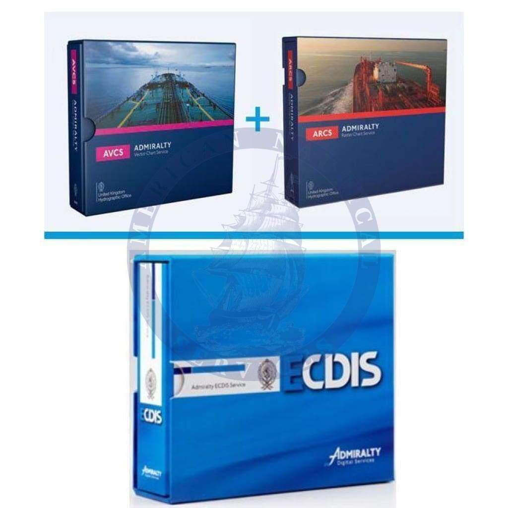
The Admiralty Electronic Chart Display and Information System (ECDIS) Service provides a comprehensive package of digital charts tailored to meet the needs of mariners looking to stay compliant with the chart carriage requirements from the SOLAS convention and keep up-to-date in the digital navigation advancement in the maritime industry. The service combines both the Admiralty Vector Chart Service (AVCS) and the Admiralty Raster Chart Service (ARCS) to provide the most complete and advanced digital chart service. Raster charts and electronic navigational charts (ENCs) from AVCS and ARCS are updated regularly via Admiralty Update Service (AUS).
The Admiralty ECDIS Service allows mariners the convenience of having an entire folio of vector charts and raster charts for a geographical region from AVCS and ARCS. Most mariners operating today are familiar with previous requirements for nautical paper charts to be kept on hand at all times for an entire voyage. Keeping a complete, up-to-date set of nautical charts for a fleet of ships can be cumbersome and sometimes inefficient. Not having a proper nautical chart can delay a voyage resulting in significant costs. Modern and efficient AVCS and ARCS in the Admiralty ECDIS Service are not only more convenient and economical, they are an improved level of marine navigation precision.
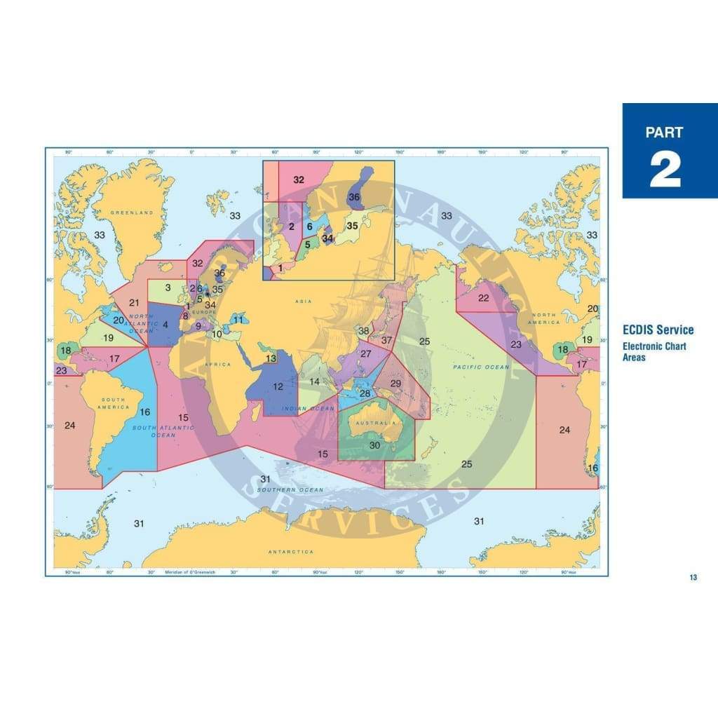
Pricing & Coverage
Access to each of Admiralty 36 regional folios is available through a series of coverage tiers:
-
Transit: All ENCs and raster charts needed for safe transit sailing. Key bunkerage and refuse ports are included.
-
Standard: All ENCs charts and raster charts needed for standard operation use are provided. The option includes key ports and approach charts as well.
-
Full: All available ENCs and raster charts are provided.

There are a small number of electronic navigation charts (ENCs) produced by hydrographic offices that are not made available in the Admiralty ECDIS Service. Please contact us for pricing details. We would be happy to discuss how the Admiralty ECDIS Service may serve your ECDIS needs.
Admiralty Information Overlay
The Admiralty Information Overlay (AIO) is a data set that contains additional navigation information to mariners. The Admiralty Information Overlay is designed to be displayed overtop of electronic navigation charts (ENCs) on an ECDIS display screen and is unique only to Admiralty ENCs. Navigation information, including all Admiralty temporary and preliminary Notices to Mariners (NTMs) and additional information that is specific to an ENC location such as navigational hazards is included to provide mariners with the most up-to-date and accurate information. AIO compatibility is dependable on what ECDIS/ECS is being used. See the table below for a list of compatible ECDIS/ECS systems.
Mariners planning routes may take advantage of information contained in AIO to make necessary changes to avoid any universal hazards. Many ECDIS systems produced before 2011 require an available upgrade to display AIO.
All in force temporary and preliminary Notices to Mariners are displayed in the Admiralty Information Overlay. Each notice to mariners is displayed as a red polygon with red hatched fill indicating the area where the Notice to Mariners is in effect. The Notice to Mariner number assigned in the Admiralty Information Overlay is the same as the number assigned in the Admiralty Notice to Mariners. Associate diagrams in Notices to Mariners may be accessed through using "Pick Report."
While all ENC services provide compliance only the Admiralty and the Admiralty Information Overlay provides mariners with the latest and most accurate information to sail confidently and safely in the toughest marine environments.
Compatible Display Systems
Both approved ECDISs as well as many non-approved electronic chart systems (ECSs) are compatible with AVCS and ARCS with Admiralty ECDIS service. Only an approved ECDIS should be used for larger vessels and commercial maritime navigation.
| Manufacturer |
Model |
Type Approved |
AVCS |
AIO |
AIO compatible ECDIS version* |
ARCS |
Installation Guide |
| Admiralty |
e-Navigator Planning Station |
|
yes |
yes |
2.4.10 |
yes |
|
| ChartWorld |
e-Globe ECDIS |
yes |
yes |
yes |
4000.10.207
ECDIS Kernel v 5.12
|
yes |
|
| Consilium |
ECDIS
S-ECDIS |
yes
yes |
yes
yes |
yes
yes |
4.5.4.27
10.2.xx |
yes
yes |
|
| Danelec |
Danelec ECDIS |
yes |
yes |
|
|
yes |
Download |
| Furuno |
FEA-2107
FEA-2807
FMD 3200
FMD 3300 |
yes
yes
yes
yes |
yes
yes
yes
yes |
yes
yes
yes
yes |
6.21
6.21
All
All |
yes
yes
yes
yes |
Download |
| Imtech |
ECDIS 3500
ECDIS 4500 |
yes
yes |
yes
yes |
|
|
yes
yes |
|
| JRC |
JAN-701B
JAN-901B
JAN-2000 |
yes
yes
yes |
yes
yes
yes |
yes
yes
yes |
ECDIS application 2.02
Maintenance no. v56
Chart portfolio 2.02 |
yes
yes
yes |
Download |
| Kelvin Hughes |
Manta Digital 20" / 22" / 26"
Manta 1700 / 2000 / 2300 |
yes
yes |
yes
yes |
|
|
yes |
Download |
| Kongsberg |
K-Bridge ECDIS |
yes |
yes |
|
|
yes |
|
| L-3 Valmarine |
NaviNet ECDIS |
yes |
yes |
|
|
yes |
Download |
| MARIS |
ECDIS900 |
yes |
yes |
yes |
4.5.3.16 |
yes |
Download |
| Offshore Systems Ltd. |
ECPINS 4000
ECPINS 5000
ECPINS-M
ECPINS-W |
yes
yes
yes
yes |
yes
yes
yes
yes |
yes
yes
yes
yes |
6.0
6.0
6.0
6.0 |
yes
yes
yes
yes |
|
| PC Maritime |
Navmaster ECDIS |
yes |
yes |
|
|
yes |
|
| Raytheon Anschütz |
NSC ECDIS Version E04.05
Synapsis ECDIS Version E04.08 |
yes
yes |
yes
yes |
|
|
yes
yes |
Download |
| SAM Electronics |
MULTIPILOT 1100 |
yes |
yes |
|
|
yes |
|
| SevenCs |
ORCA Master
(free 3 month trial available) |
|
yes |
yes |
4.5 |
yes |
Download |
| Northrop Grumman Sperry Marine |
Vision Master FT ECDIS |
yes |
yes |
|
|
yes |
Download |
| Totem Plus |
Totem ECDIS |
yes |
yes |
yes |
2.0 / AIO |
|
|
| Tokyo Keiki |
EC-8000
EC-8500 |
yes
yes |
yes
yes |
|
|
yes
yes |
Download |
| Transas |
Navi-Sailor 3000 ECDIS MFD
Navi-Sailor 4000 ECDIS MFD
Standard, Standard+, Premium, Premium+ |
yes
yes
yes |
yes
yes
yes |
yes
yes |
2.00.320.3052 |
yes
yes
yes |
Download |
|
|
|
|
|
|
|
|
* The minimum ECDIS software version number necessary to view the Admiralty Information Overlay (AIO) is specified by the AIO compatible ECDIS version number.
Some older ECDIS, particularly those built before 2009, may offer sub-par performance when installing Admiralty ECDIS service. Please contact the ECDIS manufacturer with regard to sub-par performance with ECDIS equipment that was installed before 2009.
License Information
Please see below for full information on terms and conditions from the United Kingdom Hydrographic Office:
ENC Readme file
End User Licence Agreement