
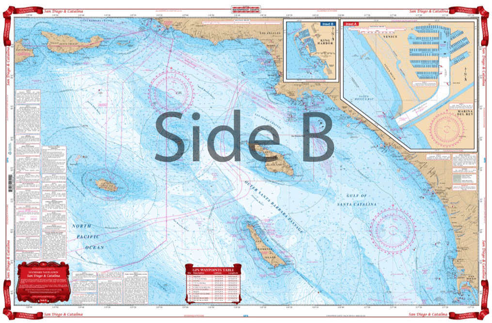
From Santa Barbara south to San Diego, this chart covers the waters offshore to San Nicholas Island with details for Santa Monica Bay and Marina Del Rey and King Harbor on one side. The reverse side details Santa Catalina Island with detailed blow ups for Isthmus Cove and Two Harbors, Avalon Bay, and Catalina Harbor. GPS Waypoints are printed directly on the chart. For journeys between San Diego and Catalina Island, this nautical map has all the detail you need. From Santa Barbara south to San Diego, this navigation chart covers the waters offshore to San Nicholas Island with details for Santa Monica Bay and Marina Del Rey and King Harbor on one side. The reverse side details Santa Catalina Island with detailed blow ups for Isthmus Cove and Two Harbors, Avalon Bay, and Catalina Harbor. GPS waypoints are printed directly on the navigation map. If you are a regular in the area, or want to remember your trip, have this navigation chart framed and display it in your home or office. Information from 3 NOAA Charts: #18740, #18744 and #18757. Nautical Chart is 25″ X 38″. WGS84 – World Mercator Datum.


Excellent Services
I wanted a quality chart delivered promptly at an acceptable price.
Mission accomplished...
Order placement and pickup was efficient and easy! I made an order mistake and they fixed it quickly for me. Hal was such a pleasure to talk to as well. Product is as described. Thanks!
My wife and I are still a few years away from casting off the dock lines on this journey, but Skipper Bob's insights have really framed my thinking about the Big Picture. I burned through the book in just a few days and have already changed some of our early planning based on the information I gleaned.
Thanks to all of you for keeping this valuable resource readily available!