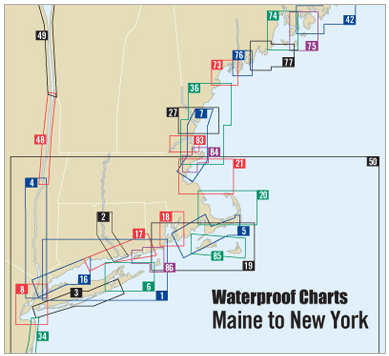
Discover the beauty and adventure of the Connecticut River with our Waterproof Chart, 8th Edition. This comprehensive chart covers the stunning stretch from Old Saybrook/Old Lyme to Hartford, CT, offering crucial navigation information for boaters and fishing enthusiasts alike.
The Connecticut River is a vital waterway, and having the right information at your fingertips is essential for safe and enjoyable outings. This waterproof chart is designed to withstand various weather conditions, ensuring you can rely on it no matter what. We understand the importance of durability in aquatic environments, which is why this chart is crafted with high-quality materials that resist wear and tear.
Key Features:
- Clearly marked "no wake zones" to help you navigate responsibly and comply with local regulations.
- A detailed key to fish species presents valuable information for anglers looking to make the most out of their fishing trips.
In addition, this chart provides information on marina and ramp locations, making it easier for you to plan your journey. At a convenient size of 14" x 60" and a scale of 1:20,000, it's user-friendly and packed with essential details. Whether you are an experienced boater or a novice navigating the Connecticut River for the first time, this Waterproof Chart is an indispensable companion.
Don’t hit the water without this reliable guide. Equip yourself with the best navigation tool available and make every aquatic adventure a safe and enjoyable experience.