
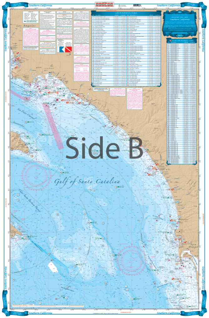

This chart covers the area south from Pt. Dume to south of Descanso, Mexico at 32 degrees north latitude and offshore 60 nautical miles. It includes a total of 444 plotted and indexed GPS positions for rocks, banks, wrecks, artificial reefs, fishing, and 171 diving locations. Added features of this chart include spot specific species and season identifiers for fish, navigation points for major harbors, high quality land detail, and much more. The combination of government charts, local knowledge, and GPS locations make this chart a great value. Whether you are a serious fisherman, or just enjoy having your line in the water, you will want this Southern California and Baja Fishing chart. This fishing chart covers the area south from Point Dume to south of Descanso, Mexico at 32 degrees north latitude and offshore 60 nautical miles. It includes a total of 444 plotted and indexed GPS positions for rocks, banks, wrecks, artificial reefs, fishing, and 171 diving locations. Added features of this marine map include spot specific species and season identifiers for fish, navigation points for major harbors, high quality land detail, and much more. The combination of NOAA charts, local knowledge, and GPS locations make this navigation chart a great value. Information from 2 NOAA charts #18740, and #18766. Nautical Chart is 25″ X 38″. WGS84 – World Mercator Datum.


Excellent Services
I wanted a quality chart delivered promptly at an acceptable price.
Mission accomplished...
Order placement and pickup was efficient and easy! I made an order mistake and they fixed it quickly for me. Hal was such a pleasure to talk to as well. Product is as described. Thanks!
My wife and I are still a few years away from casting off the dock lines on this journey, but Skipper Bob's insights have really framed my thinking about the Big Picture. I burned through the book in just a few days and have already changed some of our early planning based on the information I gleaned.
Thanks to all of you for keeping this valuable resource readily available!