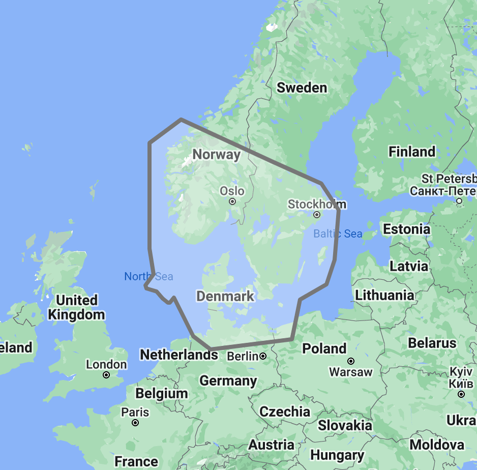
The TimeZero TZ Map: Skagerrak & Kattegat delivers comprehensive navigational coverage for the critical strait system connecting the North Sea to the Baltic, one of the busiest and most navigationally demanding waterways in Northern Europe. Built on the advanced TZ Maps platform developed by TimeZero, this chart pack integrates multiple chart types, official hydrographic raster charts, detailed vector data, high-resolution bathymetric data, and satellite imagery into a single navigational package supporting safe passage through waters where commercial shipping density, tidal currents, and restricted channel depths converge to create a uniquely challenging navigation environment.
Coverage encompasses the Skagerrak Strait between Norway, Sweden, and Denmark, the Kattegat connecting the Skagerrak to the Danish Belt passages, the Swedish west coast from the Norwegian border south through the Gothenburg archipelago to the Oresund approaches, the northern Danish coastline including the Limfjord approaches, and the Norwegian southeastern coast including the Oslofjord entrance and the approaches to Kristiansand and Arendal. This region serves as the primary gateway between the North Sea and the Baltic Sea, carrying an estimated 70,000 to 90,000 vessel transits per year through its major traffic separation schemes while simultaneously hosting one of the highest concentrations of recreational sailing traffic in Scandinavia during the summer months.
Raster data within the TZ Map is georeferenced, featuring digital images of official hydrographic office charts from three national services: the Norwegian Mapping Authority (Kartverket), the Swedish Maritime Administration (Sjofartsverket), and the Danish Geodata Agency (Geodatastyrelsen). These charts represent three distinct cartographic traditions and update cycles, and TZ Maps integrates all three into a seamless navigational package that eliminates the coverage gaps and style transitions mariners encounter when managing separate national chart folios for a single transit passage.
Vector data complements raster imagery with a layered database recording every nautical feature, delivering queryable depth information, traffic separation scheme boundaries, restricted area designations, and navigational object data across the full coverage area. The BathyVision feature provides dynamic 3D bottom data display essential for navigating the variable-depth channels, shallow coastal approaches, and rock-strewn archipelago passages that characterize the Skagerrak and Kattegat region.
Compatible with TimeZero Navigator v5 and TimeZero Professional v5 software (sold separately).
Overview
Feature Highlights Strip
Navigate with integrated raster and vector chart data sourced from official hydrographic offices and enriched with detailed nautical features.
Visualize the bottom structure with high-resolution bathymetry and BathyVision 3D contour mapping for coastal and harbor approach navigation.
Overlay satellite photography with chart data for realistic visual identification of ports, anchorages, and coastal landmarks.
View realistic shoreline altimetry and perspective horizons to identify port entries and channel approaches from offshore.
Customize chart display by toggling between raster imagery, vector layers, bathymetric overlays, and satellite views within TimeZero software.
Compatible with TimeZero Navigator v5 and TimeZero Professional v5, purpose-built for recreational and professional navigation applications.
High-Resolution Bathymetry
Navigate Strait Channels and Shallow Approaches with Confidence
High-resolution bathymetric data transforms chart contour lines into intuitive 3D bottom representations, providing essential depth awareness when navigating into Scandinavian ports, archipelago anchorages, and the depth-restricted strait passages that connect the North Sea to the Baltic. The graphic interpretation of contour data creates detailed bottom profiles invaluable for approach planning and transit routing in waters where the seabed terrain directly dictates which channels are available to deep-draft vessels.
The BathyVision feature displays bottom topography in color and contour line overlays, allowing mariners to dynamically adjust the visualization to suit their navigation needs. This capability is particularly critical in the Skagerrak and Kattegat, where the Kattegat’s average depth of approximately 23 meters creates draft restrictions that affect routing decisions for commercial vessels throughout the strait system, the Norwegian Trench running through the Skagerrak drops to over 700 meters, creating extreme depth gradients between the deep central channel and the shallow coastal margins, and the Swedish west coast archipelago presents rock-bound channels where precise depth awareness prevents grounding on unmarked granite shoals.
Mariners transiting the Oresund approaches, entering the Gothenburg fairway through the outer archipelago, or navigating the shallow Danish coastal passages toward the Limfjord, benefit from bottom structure visualization that flat chart views cannot replicate. For commercial vessels managing under-keel clearance through the strait system, BathyVision provides the kind of continuous depth context that supports safe speed and routing decisions in restricted waters.
Raster and Vector Chart Fusion
Official Charts Enhanced with Intelligent Data Layers
TZ Maps combines two complementary chart formats to deliver maximum navigational confidence. Georeferenced raster data presents true-color digital copies of official hydrographic office paper charts from Kartverket, Sjofartsverket, and Geodatastyrelsen, the same familiar chart views that mariners navigating Scandinavian waters have relied on for decades. These images provide a reliable visual reference that experienced navigators can interpret immediately.
Vector data operates alongside raster imagery using a database-driven approach that stores information in discrete layers and records every nautical feature independently. This format enables interactive chart queries, object-based search, and depth value interrogation that static raster imagery cannot provide. In the Skagerrak and Kattegat, where traffic separation schemes, precautionary areas, and pilot boarding zones create complex regulatory overlays on top of physical navigation challenges, the ability to query individual chart objects provides operational value beyond what traditional raster charts offer.
The tri-national coverage area means mariners regularly cross between Norwegian, Swedish, and Danish chart jurisdictions during a single transit. TZ Maps integrates these three national datasets seamlessly, eliminating the abrupt style changes, datum transitions, and coverage boundary gaps that occur when switching between separate chart folios mid-passage.
Satellite Photo Overlay
See the Real Landscape Behind the Chart
TZ Maps fuses satellite photography with raster and vector chart data, presenting only the visual information essential for safe navigation. Standard-resolution satellite images are included in every TZ Maps data pack, with high-definition options available for selected areas.
This overlay capability proves especially valuable in the Skagerrak and Kattegat, where visual identification of harbor breakwaters, marina entrances, and anchorage positions against the low-lying Danish coastline and the rocky Swedish archipelago aids safe approach navigation. Mariners arriving at unfamiliar harbors along the Swedish west coast, distinguishing the correct channel entrance through the Gothenburg archipelago, or identifying the approach to Danish harbors from offshore, can correlate chart data with actual terrain appearance before committing to the final approach. In the complex island landscape of the Bohuslan coast, where dozens of narrow passages wind between granite islands, satellite overlay provides the visual confirmation that helps mariners match chart symbols to real-world features.
Realistic Shoreline Views
Identify Port Entries and Coastal Features from the Horizon
TZ Maps employs altimetry to render shorelines with realistic elevation perspective, creating 3D views that simulate the visual horizon as seen from the bridge. This perspective rendering aids instant identification of port entrances, channel openings, and specific shoreline landmarks during approach.
The Skagerrak and Kattegat present two contrasting coastal profiles. The Norwegian coast rises steeply with high-relief terrain that is visually distinctive but presents multiple fjords and harbor entrances that can be difficult to differentiate from seaward. The Danish coast is predominantly low and flat, where harbor entrances present a minimal visual profile from offshore and can be difficult to identify until close approach. Altimetric rendering addresses both challenges by providing visual previews calibrated to the actual terrain elevation, helping mariners distinguish the correct approach point, whether they are making landfall against a mountainous Norwegian backdrop or searching for a harbor entrance along a featureless Danish shore.
Detailed Land Information
Understand the Coastline and Nearby Infrastructure
Beyond waterway navigation data, TZ Maps integrates detailed land information that enhances understanding of coastlines and nearby infrastructure. Road networks, settlement locations, and coastal facility positions are rendered alongside maritime chart data.
This integrated land detail supports voyage planning across the Skagerrak and Kattegat, where mariners transit between three countries with distinct port facilities, fuel availability, customs requirements, and marine service infrastructure. Understanding which harbors offer fuel bunkers, which have customs clearance for non-Schengen arrivals, and which provide haul-out or repair facilities is essential when planning passages through a region where port options are numerous but unevenly equipped.
Software Compatibility
Purpose-Built for TimeZero Navigation Software
The TZ Map: Skagerrak & Kattegat is designed for use with TimeZero navigation software platforms. Compatible applications include:
TimeZero Navigator v5: Full-featured navigation software for recreational and professional mariners
TimeZero Professional v5: Advanced navigation platform with commercial vessel capabilities
TZ Maps are delivered as data packs that load directly into compatible TimeZero software installations. This chart pack is not compatible with standalone chartplotters from other manufacturers. Mariners using Garmin, Raymarine, Simrad, or other hardware-based chartplotters should consult the ANS digital charts catalog for compatible chart products.
Need assistance determining the right chart format for your bridge electronics? Contact the ANS navigation team for personalized guidance on matching chart products to your vessel equipment.
Combine with TZ Map: Baltic Sea for complete North Sea-to-Baltic coverage through the Danish straits and across the full Baltic basin. Add TZ Map: Norway for the Norwegian coast north of the Skagerrak, TZ Map: British Islands for North Sea crossings, or TZ Map: Iceland | Greenland for high-latitude passages. Multiple TZ Map packs load seamlessly within the same TimeZero software installation.
Scandinavian Cruising Guides
Supplement digital chart data with detailed anchorage descriptions, approach instructions, and local facility information from dedicated Scandinavian cruising guides available through ANS.
ADMIRALTY Paper Charts: Skagerrak & Kattegat Coverage
Commercial vessels subject to SOLAS chart carriage requirements should maintain official paper chart backup for primary navigation areas. ADMIRALTY charts covering the Skagerrak, Kattegat, and Danish straits are available through the ANS Chart Selector.
Need Help Choosing the Right Charting Solution?
The ANS navigation team provides personalized guidance on chart selection, software compatibility, and compliance requirements for vessels of all types. Whether outfitting a yacht for Scandinavian coastal cruising or equipping a commercial vessel for North Sea-Baltic transit operations, ANS specialists match chart products to your vessel, cruising plans, and bridge electronics.
Phone: +1 (954) 522-3321
WhatsApp: +1 (954) 292-4212
Email: sales@amnautical.com
Hours: Mon-Fri 8 am-5 pm | Sat 9 am-5 pm EST
FAQs
Q1. What areas does the TZ Map: Skagerrak & Kattegat cover?
This chart pack provides navigational coverage for the Skagerrak Strait between Norway, Sweden, and Denmark, the Kattegat connecting to the Danish Belt passages, the Swedish west coast including the Gothenburg archipelago and Bohuslan coast, the Norwegian southeastern coast including the Oslofjord entrance, and the northern Danish coastline.
Q2. What software is required to use TZ Maps?
TZ Maps require TimeZero Navigator v5 or TimeZero Professional v5 software installed on a compatible computer system. TZ Maps do not operate on standalone chartplotters from other manufacturers.
Q3. Can TZ Maps be used for SOLAS chart carriage compliance?
TZ Maps are designed for navigation planning and situational awareness. Vessels subject to SOLAS Chapter V carriage requirements should verify that their chart products and navigation equipment meet applicable flag state standards. Contact ANS for guidance on SOLAS-compliant chart solutions.
Q4. What chart data types are included in the TZ Map pack?
Each TZ Map pack integrates georeferenced raster charts (official hydrographic office imagery from Norwegian, Swedish, and Danish national services), vector chart data, high-resolution bathymetry with BathyVision 3D display, satellite photography overlay, and detailed land information, including coastline features and infrastructure.
Q5. Can multiple TZ Map regions be used simultaneously?
Multiple TZ Map data packs can be installed within the same TimeZero software environment, providing seamless coverage transitions when navigating between regions. Combining the Skagerrak & Kattegat pack with TZ Map: Baltic Sea provides complete coverage from the North Sea approaches through the Danish straits and across the full Baltic basin. Adding TZ Map: Norway extends coverage along the full Norwegian coast.
I ordered a print on demand Admiralty chart, it shipped within hours! I was a little worried when I saw the outer box was bent in the middle. Turns out the chart was in plastic and inside a cardboard tube in perfect condition! Nice work in every area!