
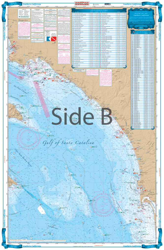

This chart covers the area south from Pt. Dume to south of Descanso, Mexico at 32 degrees north latitude and offshore 60 nautical miles. It includes a total of 444 plotted and indexed GPS positions for rocks, banks, wrecks, artificial reefs, fishing, and 171 diving locations. Added features of this chart include spot specific species and season identifiers for fish, navigation points for major harbors, high quality land detail, and much more. The combination of government charts, local knowledge, and GPS locations make this chart a great value. Whether you are a serious fisherman, or just enjoy having your line in the water, you will want this Southern California and Baja Fishing chart. This fishing chart covers the area south from Point Dume to south of Descanso, Mexico at 32 degrees north latitude and offshore 60 nautical miles. It includes a total of 444 plotted and indexed GPS positions for rocks, banks, wrecks, artificial reefs, fishing, and 171 diving locations. Added features of this marine map include spot specific species and season identifiers for fish, navigation points for major harbors, high quality land detail, and much more. The combination of NOAA charts, local knowledge, and GPS locations make this navigation chart a great value. Information from 2 NOAA charts #18740, and #18766. Nautical Chart is 25″ X 38″. WGS84 – World Mercator Datum.


I bought this book as a gift for someone who for years had had his own sailboat. He wrote to thank me for it, saying that the photos were fantastic and that he loved the book. The Black and White photography makes the photos stand out and the photos are understated and unique. Truly a wonderful book.
American National Services offered the best price on Murphy’s study guide books. They arrived quickly and in perfect condition. Can definitely recommend going through ANS. It’s worth it for your maritime career!
(Model Course 3.11) Safety Investigation into Marine Casualties and Incidents, 2014 Edition
Product arrived promptly and was current and in good condition… But the cost to ship seems excessive and more than the real cost to ship adding profit to the sale no doubt. If as they say this is a small business shipping labor is a part of the business and anything other than the cost of the actual UPS or USPS cost is an additional charge. They do have a lot of products and they do act promptly with as promised service and delivery.
It took four days for the package to get to my address in Brazil. That’s amazing!