
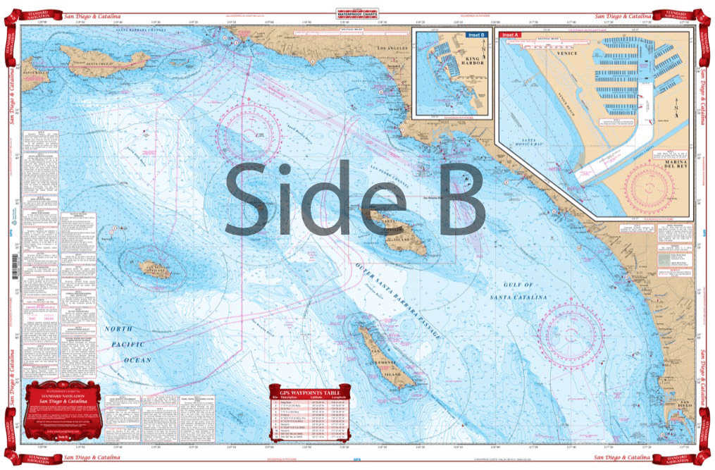
From Santa Barbara south to San Diego, this chart covers the waters offshore to San Nicholas Island with details for Santa Monica Bay and Marina Del Rey and King Harbor on one side. The reverse side details Santa Catalina Island with detailed blow ups for Isthmus Cove and Two Harbors, Avalon Bay, and Catalina Harbor. GPS Waypoints are printed directly on the chart. For journeys between San Diego and Catalina Island, this nautical map has all the detail you need. From Santa Barbara south to San Diego, this navigation chart covers the waters offshore to San Nicholas Island with details for Santa Monica Bay and Marina Del Rey and King Harbor on one side. The reverse side details Santa Catalina Island with detailed blow ups for Isthmus Cove and Two Harbors, Avalon Bay, and Catalina Harbor. GPS waypoints are printed directly on the navigation map. If you are a regular in the area, or want to remember your trip, have this navigation chart framed and display it in your home or office. Information from 3 NOAA Charts: #18740, #18744 and #18757. Nautical Chart is 25″ X 38″. WGS84 – World Mercator Datum.


I bought this book as a gift for someone who for years had had his own sailboat. He wrote to thank me for it, saying that the photos were fantastic and that he loved the book. The Black and White photography makes the photos stand out and the photos are understated and unique. Truly a wonderful book.
American National Services offered the best price on Murphy’s study guide books. They arrived quickly and in perfect condition. Can definitely recommend going through ANS. It’s worth it for your maritime career!
(Model Course 3.11) Safety Investigation into Marine Casualties and Incidents, 2014 Edition
Product arrived promptly and was current and in good condition… But the cost to ship seems excessive and more than the real cost to ship adding profit to the sale no doubt. If as they say this is a small business shipping labor is a part of the business and anything other than the cost of the actual UPS or USPS cost is an additional charge. They do have a lot of products and they do act promptly with as promised service and delivery.
It took four days for the package to get to my address in Brazil. That’s amazing!